

This information is NOT for those critics who have set their hearts against the truth. No matter how strong the evidence, it would be wasted on them. The battle lines have been drawn and the ranks are becoming clearly defined. The answers in this section are presented for the benefit of the countless honest folks who genuinely want to know the truth concerning the Discoveries claims. This includes many who are sharing the news and need extra information for genuine enquirers.
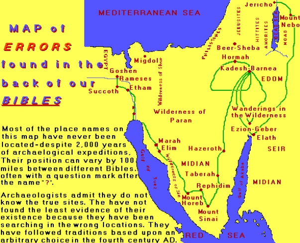
1) How do you know that the traditional site of where Mt.Sinai is, is not located in the Sinai Peninsula?
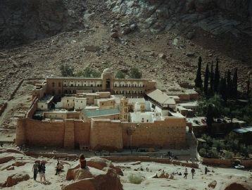
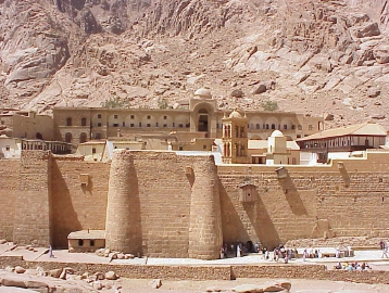
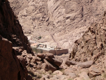
In the late 1960’s & 1970’s when Israel controlled the Sinai Peninsula, the whole area was systematically explored and intensely examined by archaeologists. No remains of the Exodus was found. Not a single one of the features of the sacred mount, such as the cave, the grazing ground, the brook, the large camp-site, etc, can be found at or around the traditional site at St. Cathrine’s mount.
In fact, none of these identifications can be found anywhere in Sinai – on any mountain. There was nothing to indicate that two million people had made camps, fought battles and marched around the desert for 40 years. This site is nothing but a tourist attraction, and probably represents the longest running confidence trick in history.
Unknown to most the reason why this site was chosen, was due to one man. Back in the fourth century, Roman Emperor Constantine acquired the notion that he was blessed with divine powers, like Moses. It seems that he had a dream one night in which he imagined that he saw the exact site of the Biblical Mt. Sinai. So he immediately sent his mother Helena to the Middle East to establish a church in the south central Sinai Peninsula. This is how this unimpressive mound of rocks became known as the true Biblical Mt. Sinai.
Two centuries later, in 527 AD, Justinian established St. Cathrine’s Monastrey on the site of Helena’s small church.

2) How do you know that the REAL Mt. Sinai, is in Saudi Arabia (Midian)?
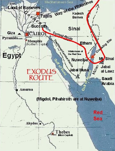
After the Israelites crossed the Red Sea, they went to Mt.Sinai (Please refer to RED SEA CROSSING FAQS for further information)
The Bible tells us in Galatians 4:25 “For this Agar is mount Sinai in Arabia, and answereth to Jerusalem which now is, and is in bondage with her children”
Notice the map. If they crossed the Red Sea, they went to Mt. Sinai.
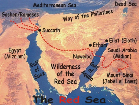

When Moses fled from Egypt, he knew that he would be safe in Midian. Obviously, this was a place where the Egyptians had no control. But where was Midian?
It was in Midian that Moses encountered the burning bush. There, God told Moses that he was to bring forth the Hebrews out of Egypt;
“When you have brought forth the people out of Egypt, you shall serve God upon this mountain” Exodus 3:12
Notice Moses was told to lead his people back to a mountain in Midian – to the mountain where God first spoke to him. This is later called Mt.Sinai.
From studies of ancient Egyptian history, it becomes clear that Midian was NOT in the so-called “Sinai Peninsula”. All through the Sinai Peninsula there is tremendous evidence of the ancient Egyptians having control of this area. The inscriptions tell of their mining there. They mined turquoise and copper. Slag heaps still remain from their smelting. There are temples out there, as well as fortresses. This was Egyptian controlled territory.
The statement that Midian was in Saudi Arabia accords with evidence from later in the Old Testament when Gideon and the Israelites faced attacks by the Midianites who came up from the desert east of the Jordan river into the land of Israel – and not from the direction of the present day Sinai Peninsula (Judges 6:33)
“….the land west of line from the Wady of Egypt to the Elanitic Gulf (the Gulf of Aqaba) has always belonged to the Egyptian political sphere, and actually that is the present boundary of Egypt….the South-Arabians called the same region Msr, i.e. Misraim, Egypt.” (James Montgomery, Arabia and the Bible, University of Pennsylvania Press, 1934, p.31)
Thus, the traditional Sinai site has been always Egyptians. Over the years many historians and scholars have realized the traditional site of Mt.Sinai in the Peninsula between the two gulfs of the Red Sea is misplaced and untenable.
“It has long been felt difficult that the Sinaitic Peninsula could have been the scene of the wanderings of the immense body of Israelites, as described, and a careful study of the biblical narratives has raised questions which have not been adequately answered. Analysis has made it probable that Kadesh-Barnea (50m. S. of Beersheba) was the scene of some of the most important incidents now placed at Sinai, and the mount of the law-giving, or, perhaps, more especially Mt.Horeb, should possibly be looked for in Midian, east of the Gulf of Akaba” Encyclopedia Britannica (Vol.20, p. 703d)
Again in the Biblical account Mt.Sinai is closely connected to with the land of Midian.
1. Moses had fled from Egypt to Midian (Exodus 2:15). His new life as a shepherd, brought him to the “mountain of God, even Horeb” (Exodus 3:1) It was here, at the burning bush, that God told Moses, “When you have brought forth the people out of Egypt, you shall serve God upon this mountain” (Exodus 3:12)
2. Later, the Israelites were brought to Horeb, Midian, and the Mount of God (Exodus 17:6; 18:1-5). It’s the same place!
3. The book of Malachi 4:4 identifies Horeb with Sinai, the mountain of the law-giving. The map image on the RIGHT is the correct one.
3) What other evidence is there that Mt.Sinai is in Saudi Arabia (Midian)?
Here is the first clue: “The Lord spoke to us in Horeb, saying, you have dwelt long enough IN this mount” Deuteronomy 1:6
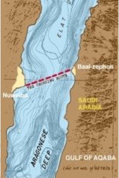
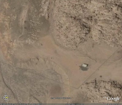
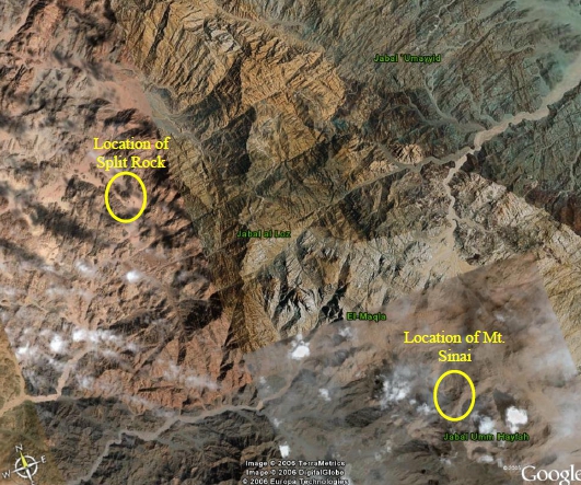
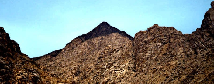
The description indicates that the people were “in” a mountain range – protected within its boarders. After the discovery of the chariot parts in the Gulf of Aqaba, Ron Wyatt went looking for a mountain on the eastern side of the gulf which would fit this description. There was only one candidate in his opinion – ‘JEBEL-EL-LAWZ’ (modern day Mt.Sinai)
An aerial map showed this mountain to be in an almost semi-circular shape, enclosing an area of 5,000 acres – certainly quite large enough to accommodate 2 million people and their herds. It was also separated from the mountainous region which paralleled the Red Sea, by a desert, or plain area – which could be the desert of Sinai. Jebel-el-lawz was the perfect candidate.
At 8,000 feet (2,600 m) it is also the tallest mountain in the region. Those who have looked up at its massive granite slopes are awed by its sheer ruggedness and size. The site is located some 144 km by road from Tabuk towards Hagi. Then, soon after crossing a bridge, a dry wadi is followed west for 48.7 km.

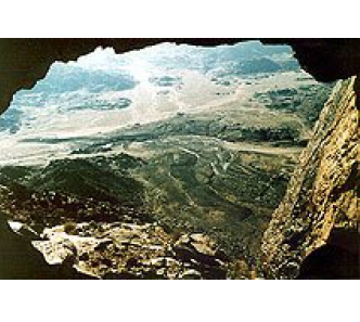
CAVE
Among other features of the site is a cave just below one peak. “And he [Elijah]…..went….unto Horeb the mountain of God. And he came thither unto a cave, and lodged there.” 1st Kings 19:8-9

SOLITARY TREE
On one of the peaks (above the cave) there are two extremely large boulders with a solitary tree growing between them. This strange tree which seemingly is growing out of granite, is one of the first things Ron Wyatt noticed when he first saw this mountain. It is this tree which positively identifies the mountain. In an area with kilometers and kilometers of mountains, there is no mistaking this particular site. When you see the tree, you know you are there.
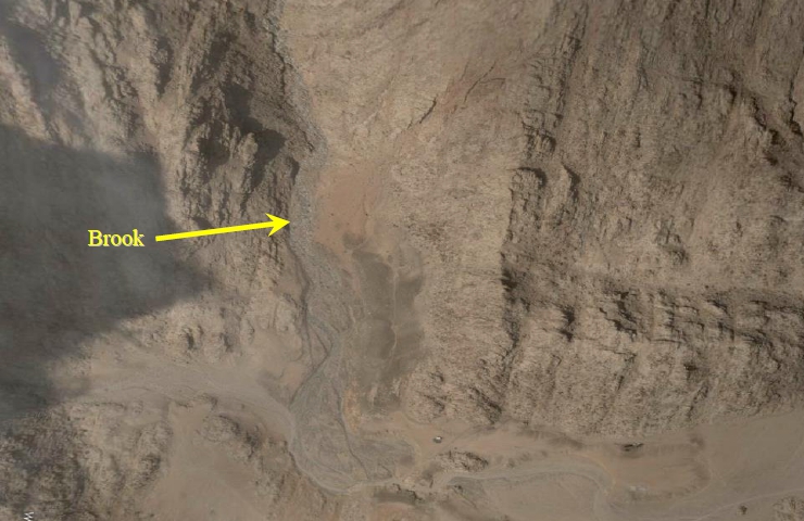
THE ANCIENT BROOK
On the face of the mountain, there extends evidence of an ancient stream that originated high in the mountain. The waters spilled down through the southern part of the holy precinct, turning east and flowing to the edge of the boundary markers (which we’ll discuss soon), then turning and flowing north. The path is still visible today.
The Biblical account tells us that when Moses destroyed and powdered up the golden calf, he “cast the dust thereof into the brook that descended out of the mount” Deuteronomy 9:21

WATER SUPPLY
Today the region is arid – not a stream anywhere!
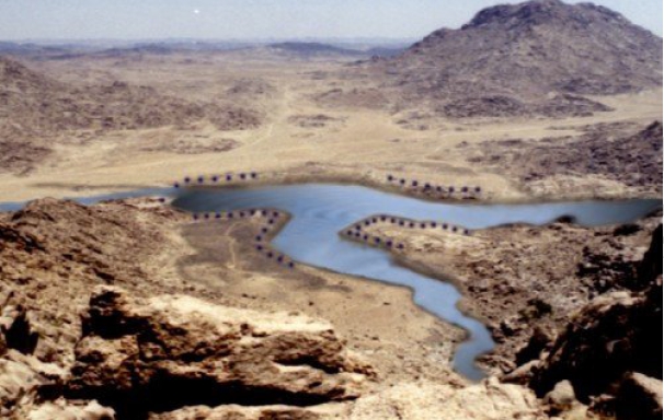
There is evidence of a very elaborate water supply system, complete with a lake and wells.
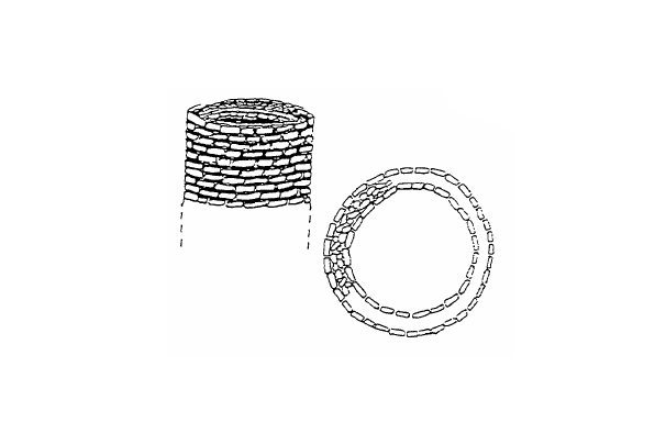
In 1985, there were found a large number of very large stone “columns” with just a few inches extending above the ground. A line of these extended along the lake boarding the “holy precinct”. Several more were on the other side of the lake, and there was a line of them many hundreds of feet from the lake.
They are double-walled and buried in the earth. Their location can be seen quite easily, as the soil covering them drops off about 20 feet (6 metres) along their entire course.

The great multitude had just come from Egypt, a country very dependent on the ability to divert water into reservoirs and canals. And it makes perfect sense to think that they employed that technology at the place that would be their home for almost a year. Two million people or more, with their animals, needed water and a LOT of it every day.
THE ALTAR FOR THE GOLDEN CALF
A dramatic event occurred while Moses was up the mountain receiving the tablets of the Ten Commandments. The people built an altar for the worship of an Egyptian golden calf;
“And Moses turned, and went down from the mount, and the two tables of the testimony were in his hand, the tables were written on both their sides…. And Joshua heard the noise of the people as they shouted, he said unto Moses, There is a noise of war in the camp. And he said, It is not the voice of them that shout for mastery, neither is it the voice of them that cry for being overcome; but the noise of them that sing do I hear. And it came to pass, as soon as he came nigh unto the camp, that he saw the calf, and the dancing: and Moses anger waxed hot, and he cast the tables out of his hands, and brake them beneath the mount. And he took the calf which they had made, and burnt it in the fire, and ground it to powder, and strewed it upon the water, and made the children of Israel drink of it” Exodus 32:15-20
We can visualize Moses and Joshua looking out over the area from the plateau (partway down the mount), getting ready to begin their final descent. They look out over the uninhabited holy precinct, and just beyond the boundary fence, the people are in a great commotion, singing and dancing. And just beyond, nestled close to a small hill, is the golden calf altar. As they walk through the holy precinct, closer to the barrier, they can clearly see the golden calf high upon the altar.
Moses throws down the Tables of Stone just inside the holy precinct, but in sight of the people. He keeps walking straight ahead, directly to Aaron and the altar. Taking the golden calf, he has hurled it into the fire, and ultimately it is melted down into a formless blob (showing what a “powerful god” it really is). Now he climbs onto the altar Aaron built and grinds the golden blob down into the dust. He then takes a large pile of gold dust to the stream which flows from the mountain and strews it in the water at the place where the stream flows out of the holy precinct. Since no one can venture beyond the barrier, no one who drinks the water can escape the pollution of gold in it.
Thus far, the evidence at Jebel-el-lawz fits the Biblical description perfectly!
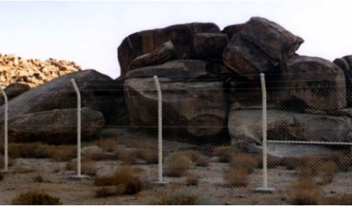
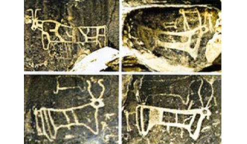
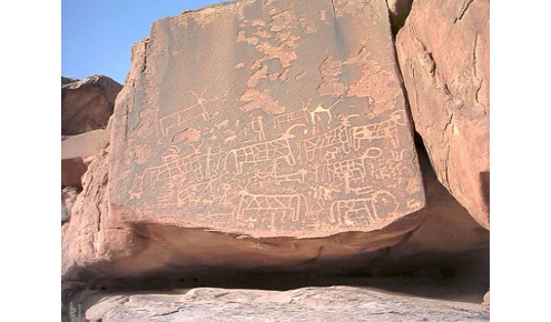
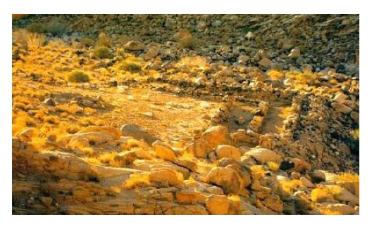
Just outside the holy precinct, perhaps a mile or more from the base of the mountain, is an ancient altar, with 12 petroglyph’s of cows and bulls. There is little doubt that this was the altar to the golden calf which Aaron had constructed, since it was obvious that the stones had been arranged.
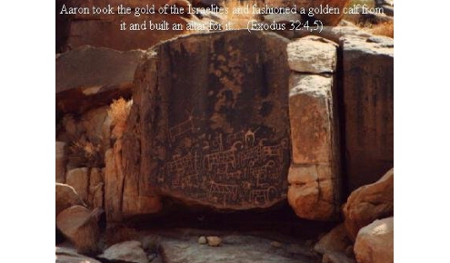
But there was more exciting evidence: When Ron Wyatt climbed upon the altar and looked over the top of it, something red and glimmering caught his eye. He saw that there was a slight puddle of water from the light, early morning shower, on the rock and it looked almost like a puddle of blood. Carefully examining this, he saw that this part of rock had a slight depression in it, which looked as if something had worn or ground it down.
Then as he looked even closer, he saw that the “blood red” colour reflected in the water was the result of tiny flecks of gold embedded in the entire worn area. (6′ X 4′) of the top of the rock. Was this where Moses had ground down the golden calf into gold powder, before making the people to drink it? (Exodus 32:20)
When Ron Wyatt showed the archaeologist from Riyadh University, he was very excited. He said this ancient Egyptian style of petroglyph was found NOWHERE ELSE in Saudi that he knew of. The horns of the cows and bulls were drawn in the Egyptian style, representing the gods Hathor and Apis.
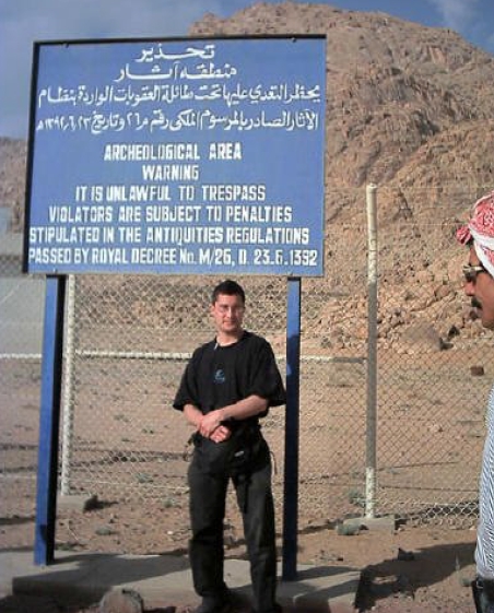
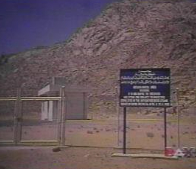
Ron was congratulated on the discovery and the area was promptly closed off. All photographs were confiscated. The cost involved in the fencing alone shows that the Saudis are taking this site very seriously.
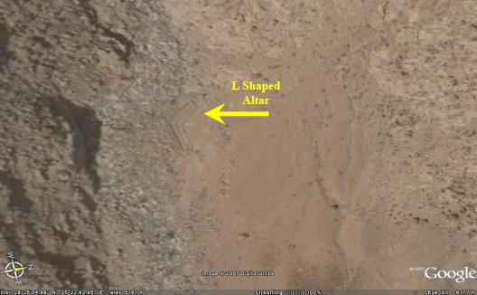
ALTAR AT THE FOOT OF THE MOUNTAIN
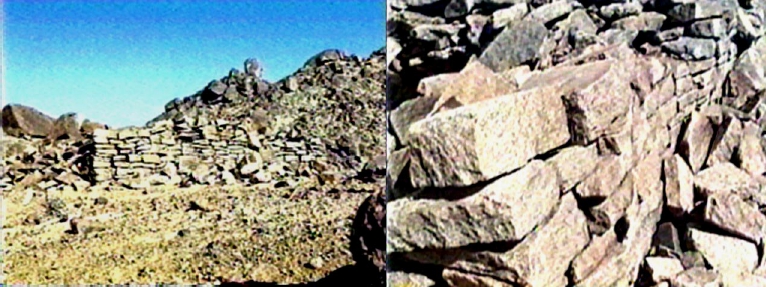
Outside the camp, under the mount, is an altar, about 40 to 45 inches high, and roughly 50 to 60 feet long and 25 to 30 feet wide, made of uncut stones. The Scripture mentions this altar of “unhewn” stone, “under the hill” (Exodus 20:25, 24:4).
Adjoining it to form an “L”shape is a “corral” with walls about 3 feet thick and a dividing wall down lengthwise, one corridor probably for entry with the sacrificial animal, the other for exiting. At the entrance to the “corral” are two “U” shaped stones with centre holes, presumably for the placing of the animals head and then for removal of blood when it was killed.

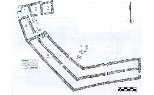
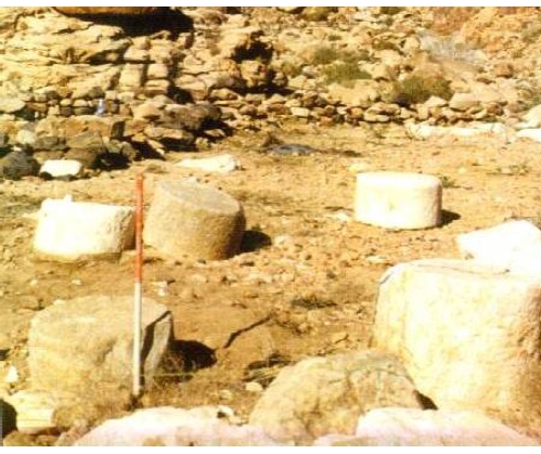
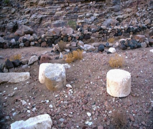
THE 12 PILLARS
The Bible records: “And Moses….builded an altar under the hill, and twelve pillars, according to the twelve tribes of Israel” Exodus 24:4
The Hebrew word used is “matstsebah”. Could this be the origin of the word “massebah”, which denotes a one-piece, standing pillar? (cf. Josuha 4:8)
Discovered: In the holy precinct, to the far right and near the front (looking westward into the area) there is a semi-circle of 12 large granite boulders; about 6 feet wide and 9 foot tall. (This is an estimate based on the drop in ground level). These are covered by alluvial soil, washed into the area by seasonal showers – and only the tops are visible.
Ron saw these white pillars lying close to ground level, as the sun reflected off the white stone.
CIRCULAR DWELLINGS
There are thousands of circular dwelling remains of the multitudes stay at Sinai and Rephidim.
“THE ROCK OF HOREB”
Tracking Israel’s route from the Red Sea to Sinai in Arabia, we find ourselves in a place which fits the description of Rephidim. Here, in the desert, Moses was told to go to “the rock in Horeb” (undoubtedly, a well-known, prominent rock) and strike it. He was promised that out would come water for the people to drink.
Here stands the most amazing monument on this planet!
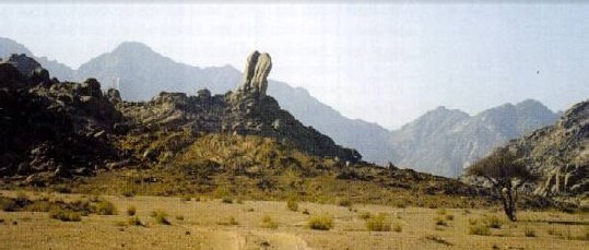
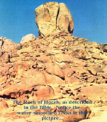
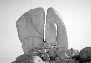
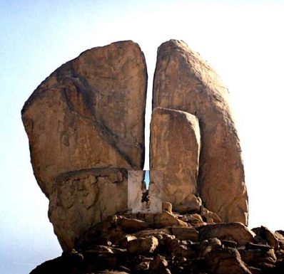
On the western side of the Horeb range (the encampment at Mt.Sinai was on the east), in the midst of the plain, is a hill about 110 feet (34 m) high. A top this hill towers a mighty rock, about the size of an 5 story building. The total height, then, of this object, is about 16 stories.
This giant rock is split through the middle. The split is large enough for a man to walk through. Now, here is the remarkable part: Water erosion channels come from the TOP of the hill – OUT OF THE ROCK! This displays the pattern of water erosion, with evidence that numerous streams came forth in several directions.
Today, there is no water in the region anywhere. For this reason, it has remained uninhabited all these years. But it is evident that great streams of water once came from this split in the rock in several directions. The erosion channels continue out into the plain below.
ANOTHER ALTAR
About 200 meters from this rock, is another altar, similar in construction to the one in the holy precinct. The Scripture says that Moses built an altar at Rephidim. And that altar is still there.
The Biblical account gives us a CHECK-LIST of items that were left behind by the Hebrews on their march from Egypt and Canaan. We have discovered that the weight of evidence supports the story to its minutest detail. Discovery after discovery vindicates the accuracy of this inspired record.
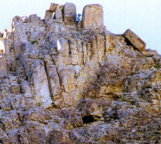
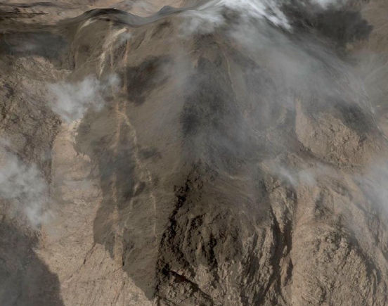
4) What caused the blackened top of mountain?
The entire top of the mountain is blackened as if charred by some tremendous heat. It looks like it is made of coal. It looks exactly as if the very top portion of the entire top of the mountain had been evenly scorched.
Notice the biblical account:
“And Mount Sinai was altogether on a smoke, because the LORD descended upon it in fire” Exodus 19:18.
Mount Sinai “melted” (Judges 5:5). It “burned with fire”, “unto blackness” (Hebrews 12:18). Is this burnt top the result of the consuming fire of God’s own presence?
5) How have the remains of artifacts managed to survive?
Fortunately the remoteness and the desert conditions have preserved these remains, just where they were left 3,400 years ago.
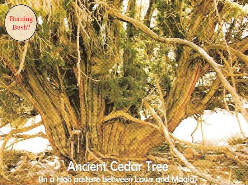
6) Has the burning bush ever been found?
In a high pasture northeast of Mt.Sinai, a huge cedar tree remains. The diameter of its trunk is over 8 feet which dates this tree in the thousands of years. It is approximately 40 feet tall and 30 feet across. It is in the right place and has the necessary age. So it could be the one.